THE TEXAS PILOTS ASSOCIATION

United States of America


Sunday November 28, 2021 17:02


NAV CNTRL PNL 2

FULL MENU

LNKDN

TWTTR

AV JOBS

RSRCS

AV WTHR

FLY TX

bullet bullet bullet bullet bullet bullet bullet bullet bullet

Our Featured Texas Airport

Archive


Dallas/Fort Worth International Airport

Corporate Aviation


The Little GA secret that even Wikipedia does not talk about to date (January 7, 2012)!
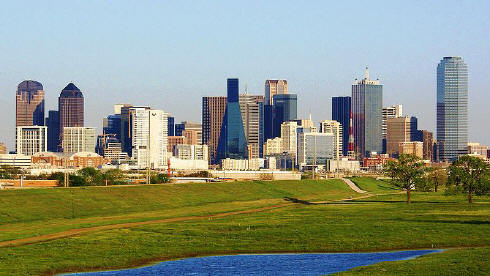


The City


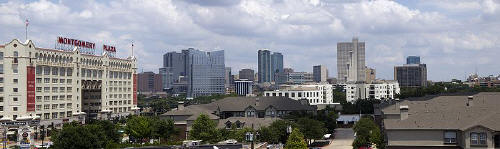
The cities of Dallas and Fort Worth are the anchor cities of the Metroplex* (Dallas-Arlington-Fort Worth). Dallas and its suburbs have one of the highest concentrations of corporate headquarters in the United States. As such, one of the largest industries in the Metroplex is conducting business. The Metroplex also contains the largest Information Technology industry base in the state (often referred to as Silicon Prairie or the Telecom Corridor), owing to the large number of corporate IT projects and the presence of numerous electronics, computing and telecommunication firms such as Texas Instruments, HP Enterprise Services, Dell Services, i2, AT&T, Ericsson, CA and Verizon in and around Dallas. On the other end of the business spectrum, and on the other side of the Metroplex, the Texas farming and ranching industry is based in Fort Worth. According to the Dallas Business Journal's 2006 Book of Lists, American Airlines is the largest employer in the Metroplex. Several major defense manufacturers, including Lockheed Martin, Bell Helicopter Textron, and Raytheon, maintain significant operations in the Metroplex. ExxonMobil, the #1 corporation on the Fortune 500 listings, is headquartered in Irving, Texas.
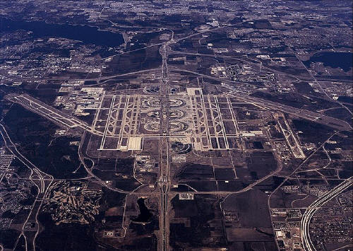
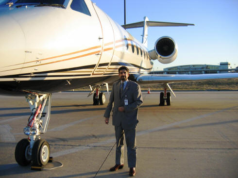
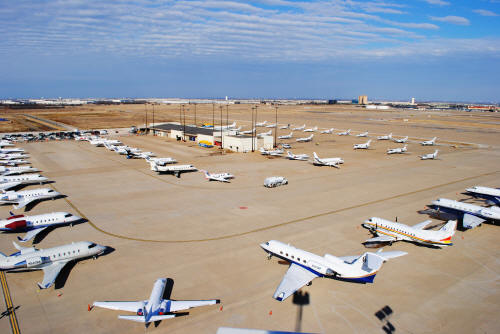
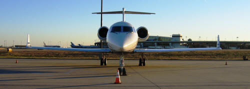


The Chairman of The TPA during a visit through DFW A/P, Corporate Aviation, on a 2012 very windy winter Texas day!


180 feet above the south end of the ramp at 15:30 on Super Bowl Sunday 2011. There were 51 aircraft on the ramp at that time with the 52nd and last aircraft to arrive taxing in to take the last available spot on the ramp that can be seen in the upper right hand side of the photo. An additional 21 aircraft were parked at two other locations on the airport designated as overflow parking during our planning for Super Bowl. DFW Corporate Aviation handled 348 operations between Friday and Monday that weekend. In 2011 they handled over 6900 operations, an increase of 18% over the previous year.


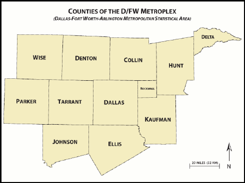
The Metroplex overlooks mostly prairie land with a few rolling hills dotted by man-made lakes cut by streams, creeks and rivers surrounded by forest land. The Metroplex is situated in the Texas blackland prairies region, so named for its fertile black soil found especially in the rural areas of Collin, Dallas, Ellis, Hunt, Kaufman, and Rockwall counties.

Many areas of Denton, Johnson, Parker, Tarrant, and Wise counties are located in the Fort Worth Prairie region of North Texas, which has less fertile and more rocky soil than that of the Texas blackland prairie; most of the rural land on the Fort Worth Prairie is ranch land. A large onshore natural gas field, the Barnett Shale, lies underneath this area; Denton, Tarrant and Wise counties feature many natural gas wells. Continuing land use change results in scattered crop fields surrounded by residential or commercial development.

South of Dallas and Fort Worth is a line of rugged hills that goes north to south about 15 miles (24 km) that looks similar to the Texas Hill Country 200 miles (320 km) to the south.


The DFW area falls in the CFa (Humid, Subtropical) region of the K?pen climate classification system which is is a climate zone characterized by hot, humid summers and mild to cool winters.


Dallas, Texas


Arlington, Texas


Fort Worth, Texas


Airport Data


bullet

DFW Corporate Aviation

Location

Airport Operations

Airport Communications

Nearby Radio Navigations Aids

Airport Services

Runway Information

Airport Ownership and Management

Airport Operational Statistics

Instrument Procedures


DFW Corporate Aviation


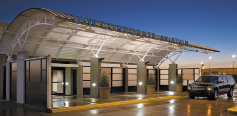
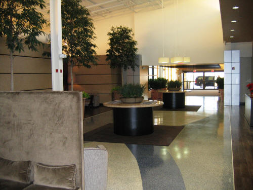
Experience the accommodations you'd expect to find at one of the worlds finest airports. Welcome to the all-new Corporate Aviation facility at Dallas/Fort Worth International Airport.


With amenities on par with those of luxury hotels, Corporate Aviation offers unparalleled comfort, relaxation and convenience. Ramp services and more than 8,500 combined square feet of meeting and lounge space await your arrival.


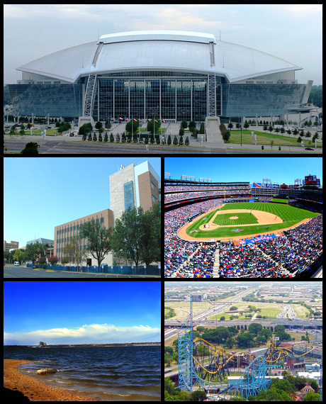
Located directly between Dallas and Fort Worth, Corporate Aviation offers immediate access to surrounding business districts, entertainment and sports venues, as well as corporate headquarters of 23 Fortune 500 companies.


Corporate Aviation provides support services for all private and corporate aircraft arriving at and departing from DFW Airport.


... Experience the difference between merely landing and truly arriving! 


Landing a Cessna-172 at DFW International Airport

-Heading to the General Aviation Facility

as you will hear during the comm with the DFW ATC


  • Services


- Aviation fuel
- Aircraft parking (ramp or tiedown)
- GPU / Power cart
- Passenger terminal and lounge
- Catering
- Rental cars
- Courtesy transportation
- Courtesy cars (free for pilots to use in the local area)
- Pilots lounge / snooze room
- Public telephone


  • Aviation fuel services


- Brand: independent
- Fueling hours: during regular business hours, plus after hours call-out service (with prior arrangement and/or a callout fee); call for details

Discounts:Volume Discount on retail fuel.
Into plane fee for contract fuel based on fuel uplift.
Landing and Facility Fees are based on Max Gross Landing Weight and are not waived with fuel purchase.


 RESERVATIONS REQUIRED FOR OVERNIGHT PARKING FOR ALL EVENTS AT COWBOYS STADIUM.

  • Contact information

Address: Corporate Aviation
1816 N.24th Avenue
DFW Airport, TX 75261-9428
United States of America
Telephone: 972-574-3390
Fax: 972-574-0267
Email: corporateaviation@dfwairport.com
Web site: http://www.dfwairport.com/corporateaviation/index.php
 
  • How To Get There?

The Corporate Aviation facility is accessible from anywhere in the DFW Metroplex by entering DFW Airport through either the north or south service roads.

To view the facility on a map, please click here.

For additional information on the facility, click here.

During times of construction please follow the detour signs for Corporate Aviation or call 972-574-8899 for more details.


From DFW's North Entrance
 
From either I-635, State Highway 114 or State Highway 121, exit to the north entrance to the Airport. Please note that due to construction at the north end of the airport the Remote North Parking Entrance will be relocated on January 8 and the South Bound Service Road Ramp from State Highway 121 (aka South International Parkway) will be closed on January 8th. To access the Southbound Service Road to Corporate Aviation or the new North Remote Parking entrance the following detours will be in place:
  • From Southbound SH 121 take SH 114 West and exit Texan Trail. Take Texan Trail to Airfield Drive eastbound to the South Bound Service Road.
  • From Eastbound SH 114 take Texan Trail to Airfield Drive and continue east to the South Bound Service Road.
  • From Westbound SH 114 take Freeport Exit south to Airfield Drive. Go west on Airfield drive to the South Bound Service Road.
NOTE: Access to DFW Airport from southbound SH 121 and westbound SH 114 will be unaffected. Traffic exiting at the DFW Airport?s north entrance will still be able to exit the airport using existing ramps.

Once established on the South Bound Service Road (bypassing the Airport?s entry toll plazas) at the first traffic light, Crossunder #1, turn left, heading east. You will then arrive at a stop sign marking the northbound Service Road intersection with Crossunder #1.
Proceed straight through the intersection, and you will now be on East 16th Street, which will turn into North 24th Ave and is the road to the DFW Corporate Aviation facility.
 

From DFW's South Entrance
  • From State Highway 183 or State Highway 360, exit to the south entrance to the Airport.
  • Exit onto the Service Road heading northbound (bypassing the Airport?s entry toll plazas).
  • Proceed north for about 4.5 miles on the Service Road, driving through three traffic lights and past Terminals E, C and A on your right.
  • After passing the American Airlines Cargo facility, take the first right turn at Crossunder #1 / East 16th Street, heading east. You will now be on East 16th Street, which will turn into North 24th Ave and is the road to the DFW Corporate Aviation facility.
Airfield Location
 
Corporate Aviation is located in the Northeast Quadrant of DFW Airport on the 1E Ramp immediately west of the Northeast holdpad. Apron Entry Point (AEP) 1 and 2 off of Taxiway Juliet, or AEP 3 and 4 off of Taxiway Yankee. The primary entrance from the ramp is on the Northeast side of the building.


Location

FAA Identifier: DFW
Lat/Long: 32-53-48.5810N / 097-02-16.7850W
32-53.809683N / 097-02.279750W
32.8968281 / -97.0379958
(estimated)
Elevation: 607 ft. / 185.0 m (surveyed)
Variation: 06E (2000)
From city: 12 miles NW of DALLAS-FORT WORTH, TX
Time zone: UTC -6 (UTC -5 during Daylight Saving Time)
Zip code: 75261

Airport Operations

Airport use: Open to the public
Activation date: 01/1974
Sectional chart: DALLAS-FT WORTH
Control tower: yes
ARTCC: FORT WORTH CENTER
FSS: FORT WORTH FLIGHT SERVICE STATION [817-541-3474]
NOTAMs facility: DFW (NOTAM-D service available)
Attendance: CONTINUOUS
Wind indicator: lighted
Segmented circle: no
Lights: DUSK-DAWN
Beacon: white-green (lighted land airport)
Landing fee: yes
Fire and rescue: ARFF index E
International operations: international airport of entry

Airport Communications

UNICOM: 122.95
WX ASOS: PHONE 972-453-0992
DFW GROUND: 121.65(EAST) 121.8(EAST) 121.85(WEST)
DFW TOWER: 124.15(WEST) 126.55(EAST) 127.5(EAST) 134.9(WEST)
REGIONAL APPROACH: 119.875(WEST) 125.025(EAST) 263.025 EAST 284.65(WEST) 133.525(EAST) 133.625(WEST)
REGIONAL DEPARTURE: 118.55(EAST) 124.825(NORTH) 125.125(SOUTH) 126.475(WEST) 290.35(EAST) 319.85(SOUTH) 323.05(NORTH) 363.15(WEST)
CLEARANCE DELIVERY: 128.25
CLASS B NE: 124.3 282.275
CLASS B NW: 118.1 306.95
CLASS B SE: 125.2 343.65
CLASS B SW: 135.975 379.9
D-ATIS: 123.775(ARR) 135.925(DEP)
EMERG: 243.0
IC: 119.875(WEST) 121.65(EAST) 121.8(EAST) 124.15(WEST) 125.025(EAST) 126.55(EAST) 127.5(EAST) 134.9(WEST)
WX ASOS at DAL (10 nm E): PHONE 214-904-0251
WX AWOS-3 at ADS (11 nm NE): PHONE 972-386-4855
WX AWOS-3 at GPM (12 nm S): 118.475 (972-606-1433)
WX AWOS-3 at 49T (14 nm SE): 135.425 (214-670-1243)
WX ASOS at GKY (14 nm S): 127.375 (817-557-0251)
WX ASOS at AFW (15 nm W): PHONE 817-491-8625
WX ASOS at RBD (16 nm SE): PHONE 214-330-5317
WX ASOS at FTW (17 nm W): PHONE 817-626-5811
  • APCH CTL PROVIDES CLEARANCE DELIVERY FOR HICKS AIRFIELD ON FREQ 125.9.
  • ASR-9 SERVES AS ADDNL ASR FOR DALLAS/FORT WORTH INTL AND ALSO SERVES DALLAS LOVE FIELD.

Nearby radio navigation aids

VOR radial/distance   VOR name   Freq   Var
TTTr358/1.7   MAVERICK VOR/DME   113.10   06E
CVEr267/6.8   COWBOY VOR/DME   116.20   06E
FUZr080/7.1   RANGER VORTAC   115.70   06E


NDB name   Hdg/Dist   Freq   Var   ID
REDBIRD   321/15.7   287   06E   RBD .-. -... -..
CEDAR HILL   342/18.6   353   08E   XQH -..- --.- ....
LANCASTER   314/24.9   239   06E   LNC .-.. -. -.-.
MESQUITE   276/26.2   248   06E   PQF .--. --.- ..-.
JECCA   292/29.0   388   06E   JUG .--- ..- --.

Airport Services

Fuel available: 100LL JET-A
Parking: tiedowns
Bottled oxygen: HIGH
Bulk oxygen: HIGH

Runway Information

Runway 17C/35C


Dimensions: 13401 x 150 ft. / 4085 x 46 m
Surface: concrete/grooved, in good condition
Weight bearing capacity:
Single wheel: 120.0
Double wheel: 200.0
Double tandem: 600.0
Dual double tandem: 850.0
Runway edge lights: high intensity
  RUNWAY 17C   RUNWAY 35C
Latitude: 32-54.942467N   32-52.732700N
Longitude: 097-01.558233W   097-01.570300W
Elevation: 561.9 ft.   562.2 ft.
Traffic pattern: left   left
Runway heading: 174 magnetic, 180 true   354 magnetic, 000 true
Declared distances: TORA:13401 TODA:13401 ASDA:13401 LDA:13401   TORA:13401 TODA:13401 ASDA:13401 LDA:13401
Markings: precision, in good condition   precision, in good condition
Visual slope indicator: 4-light PAPI on left (3.00 degrees glide path)   4-light PAPI on left (3.00 degrees glide path)
RVR equipment: touchdown, midfield, rollout   touchdown, midfield, rollout
Approach lights: ALSF2: standard 2,400 foot high intensity approach lighting system with centerline sequenced flashers (category II or III)   ALSF2: standard 2,400 foot high intensity approach lighting system with centerline sequenced flashers (category II or III)
Runway end identifier lights: no    
Centerline lights: yes   yes
Touchdown point: yes, no lights   yes, lighted
Instrument approach: ILS/DME   ILS/DME


Runway 17R/35L


Dimensions: 13401 x 200 ft. / 4085 x 61 m
Surface: concrete/grooved, in good condition
Weight bearing capacity:
Single wheel: 120.0
Double wheel: 200.0
Double tandem: 600.0
Dual double tandem: 850.0
Runway edge lights: high intensity
  RUNWAY 17R   RUNWAY 35L
Latitude: 32-54.943333N   32-52.733633N
Longitude: 097-01.793000W   097-01.804867W
Elevation: 566.5 ft.   563.3 ft.
Traffic pattern: left   left
Runway heading: 174 magnetic, 180 true   354 magnetic, 000 true
Declared distances: TORA:13401 TODA:13401 ASDA:13401 LDA:13401   TORA:13401 TODA:13401 ASDA:13401 LDA:13401
Markings: precision, in good condition   precision, in good condition
Visual slope indicator: 4-light PAPI on left (3.00 degrees glide path)   4-light PAPI on left (3.00 degrees glide path)
RVR equipment: touchdown, midfield, rollout   touchdown, midfield, rollout
Approach lights: MALSR: 1,400 foot medium intensity approach lighting system with runway alignment indicator lights   MALSR: 1,400 foot medium intensity approach lighting system with runway alignment indicator lights
Centerline lights: yes   yes
Touchdown point: yes, lighted   yes, lighted
Instrument approach: ILS/DME   ILS/DME


Runway 18L/36R


Dimensions: 13400 x 200 ft. / 4084 x 61 m
Surface: concrete/grooved, in good condition
Weight bearing capacity:
Single wheel: 120.0
Double wheel: 200.0
Double tandem: 600.0
Dual double tandem: 850.0
Runway edge lights: high intensity
  RUNWAY 18L   RUNWAY 36R
Latitude: 32-54.947950N   32-52.738300N
Longitude: 097-03.044140W   097-03.055567W
Elevation: 601.7 ft.   575.3 ft.
Gradient: 0.2%   0.2%
Traffic pattern: left   left
Runway heading: 174 magnetic, 180 true   354 magnetic, 000 true
Declared distances: TORA:13400 TODA:13400 ASDA:13400 LDA:13400   TORA:13400 TODA:13400 ASDA:13400 LDA:13400
Markings: precision, in good condition   precision, in good condition
Visual slope indicator: 4-light PAPI on left (3.00 degrees glide path)   4-light PAPI on left (3.00 degrees glide path)
RVR equipment: touchdown, midfield, rollout   touchdown, midfield, rollout
Approach lights: MALSR: 1,400 foot medium intensity approach lighting system with runway alignment indicator lights   MALSR: 1,400 foot medium intensity approach lighting system with runway alignment indicator lights
Runway end identifier lights: no    
Centerline lights: yes   yes
Touchdown point: yes, lighted   yes, lighted
Instrument approach: ILS/DME   ILS/DME


Runway 18R/36L


Dimensions: 13400 x 150 ft. / 4084 x 46 m
Surface: concrete/grooved, in good condition
Weight bearing capacity:
Single wheel: 120.0
Double wheel: 200.0
Double tandem: 600.0
Dual double tandem: 850.0
Runway edge lights: high intensity
  RUNWAY 18R   RUNWAY 36L
Latitude: 32-54.948883N   32-52.739167N
Longitude: 097-03.278513W   097-03.290017W
Elevation: 606.7 ft.   582.2 ft.
Traffic pattern: left   left
Runway heading: 174 magnetic, 180 true   354 magnetic, 000 true
Declared distances: TORA:13400 TODA:13400 ASDA:13400 LDA:13400   TORA:13400 TODA:13400 ASDA:13400 LDA:13400
Markings: precision, in good condition   precision, in good condition
Visual slope indicator: 4-light PAPI on left (3.00 degrees glide path)   4-light PAPI on left (3.00 degrees glide path)
RVR equipment: touchdown, midfield, rollout   touchdown, midfield, rollout
Approach lights: ALSF2: standard 2,400 foot high intensity approach lighting system with centerline sequenced flashers (category II or III)   MALSR: 1,400 foot medium intensity approach lighting system with runway alignment indicator lights
Runway end identifier lights: no    
Centerline lights: yes   yes
Touchdown point: yes, lighted   yes, lighted
Instrument approach: ILS/DME   ILS/DME


Runway 13R/31L


Dimensions: 9301 x 150 ft. / 2835 x 46 m
Surface: concrete/grooved, in good condition
Weight bearing capacity:
Single wheel: 120.0
Double wheel: 200.0
Double tandem: 600.0
Dual double tandem: 850.0
Runway edge lights: high intensity
Operational restrictions: CLSD 2200-0600 EXCP PPR.
  RUNWAY 13R   RUNWAY 31L
Latitude: 32-54.574533N   32-53.416167N
Longitude: 097-04.987967W   097-03.796567W
Elevation: 590.9 ft.   577.1 ft.
Traffic pattern: left   left
Runway heading: 133 magnetic, 139 true   313 magnetic, 319 true
Declared distances: TORA:9301 TODA:9301 ASDA:9301 LDA:9301   TORA:9301 TODA:9301 ASDA:9301 LDA:9301
Markings: precision, in good condition   nonprecision, in good condition
Visual slope indicator: 4-light PAPI on left (3.00 degrees glide path)   4-light PAPI on left (3.13 degrees glide path)
RVR equipment: touchdown, rollout   touchdown, rollout
Approach lights: MALSR: 1,400 foot medium intensity approach lighting system with runway alignment indicator lights    
Runway end identifier lights:     yes
Centerline lights: yes   yes
Touchdown point: yes, lighted   yes, no lights
Instrument approach: ILS/DME    


Runway 13L/31R


Dimensions: 9000 x 200 ft. / 2743 x 61 m
RY 31R LAST 625 FT CLSD INDEFLY.
Surface: concrete/grooved, in good condition
Weight bearing capacity:
Single wheel: 120.0
Double wheel: 200.0
Double tandem: 600.0
Dual double tandem: 850.0
Runway edge lights: high intensity
Operational restrictions: CLSD 2200-0600 EXCP PPR.
  RUNWAY 13L   RUNWAY 31R
Latitude: 32-54.753250N   32-53.698883N
Longitude: 097-01.288683W   097-00.050650W
Elevation: 552.9 ft.   508.1 ft.
Gradient: 0.5%   0.5%
Traffic pattern: left   left
Runway heading: 129 magnetic, 135 true   309 magnetic, 315 true
Displaced threshold: 625 ft.   no
Declared distances: TORA:9000 TODA:9000 ASDA:9000 LDA:8375   TORA:8375 TODA:8375 ASDA:8375 LDA:8375
Markings: nonprecision, in good condition   precision, in good condition
Visual slope indicator: 4-light PAPI on left (3.00 degrees glide path)   4-light PAPI on left (3.00 degrees glide path)
RVR equipment: touchdown, midfield, rollout   touchdown, midfield, rollout
Approach lights:     MALSR: 1,400 foot medium intensity approach lighting system with runway alignment indicator lights
Runway end identifier lights: yes    
Centerline lights: yes   yes
Touchdown point: yes, no lights   yes, lighted
Instrument approach:     ILS/DME


Runway 17L/35R


Dimensions: 8500 x 150 ft. / 2591 x 46 m
Surface: concrete/grooved, in good condition
Weight bearing capacity:
Single wheel: 120.0
Double wheel: 200.0
Double tandem: 600.0
Dual double tandem: 850.0
Runway edge lights: high intensity
Operational restrictions: CLSD 2200-0600 EXCP PPR.
  RUNWAY 17L   RUNWAY 35R
Latitude: 32-53.899233N   32-52.497567N
Longitude: 097-00.586733W   097-00.594517W
Elevation: 524.1 ft.   575.2 ft.
Traffic pattern: left   left
Runway heading: 174 magnetic, 180 true   354 magnetic, 000 true
Declared distances: TORA:8500 TODA:8500 ASDA:8500 LDA:8500   TORA:8500 TODA:8500 ASDA:8500 LDA:8500
Markings: precision, in good condition   precision, in good condition
Visual slope indicator: 4-light PAPI on left (3.00 degrees glide path)   4-light PAPI on right (3.00 degrees glide path)
RVR equipment: touchdown, midfield, rollout   touchdown, midfield, rollout
Approach lights: ALSF2: standard 2,400 foot high intensity approach lighting system with centerline sequenced flashers (category II or III)   ALSF2: standard 2,400 foot high intensity approach lighting system with centerline sequenced flashers (category II or III)
Centerline lights: yes   yes
Touchdown point: yes, lighted   yes, lighted
Instrument approach: ILS/DME   ILS/DME
Obstructions: 150 ft. ant, lighted, 5443 ft. from runway, 798 ft. left of centerline, 34:1 slope to clear
ANTENNA ON BUILDING.
  none

Airport Ownership and Management (FAA records)

Ownership: Publicly-owned
Owner: CITIES OF DALLAS AND FT WORTH
PO BOX 619428
DALLAS-FT WORTH, TX 75261
Phone 972-574-3200
Manager: JEFFREY FEGAN - CEO
PO BOX 619428
DALLAS-FT WORTH, TX 75261
Phone 972-973-3112

Airport Operational Statistics

Aircraft operations: avg 1931/day *
72% commercial
27% air taxi
<1% transient general aviation
<1% military
* for 12-month period ending 31 October 2010

Instrument Procedures

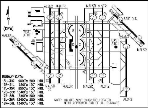
Please procure official charts for flight for: STARs - Standard Terminal Arrivals, IAPs - Instrument Approach Procedures, and Departure Procedures.

** Other nearby airports with instrument procedures:

KDAL - Dallas Love Field Airport (10 nm E)
KADS - Addison Airport (11 nm NE)
KGPM - Grand Prairie Municipal Airport (12 nm S)
KGKY - Arlington Municipal Airport (14 nm S)
KAFW - Fort Worth Alliance Airport (15 nm W)
KRBD - Dallas Executive Airport (16 nm SE)
KFTW - Fort Worth Meacham International Airport (17 nm W)


To learn more about Texas airports, please visit our Fly Texas page.


* According to the North Texas Commission (NTC), the term originated from an ad agency's combination of the terms "metropolitan" and "complex". The NTC copyrighted the term "Dallas/Fort Worth Metroplex" in 1972 as a replacement for the previously-ubiquitous "North Texas."

Srcs: Wikipedia, NavAir, and TPA records.


Archive


 © Copyright, Texas Pilots Association, All rights reserved.